Message about Przhevalsky. The great Russian traveler Nikolai Mikhailovich Przhevalsky. See what “Przhevalsky, Nikolai Mikhailovich” is in other dictionaries
A message about Nikolai Przhevalsky, about the Russian geographer and traveler, is presented in this article. You can supplement your report on Przhevalsky with interesting facts from the life of the famous explorer of Asia.
Nikolai Przhevalsky short biography
Nikolai Mikhailovich Przhevalsky was born in the village of Kimborovo on April 12, 1839 in the family of a small landowner and officer. The boy was raised by his uncle, who passionately loved hunting. The young man graduated from the General Staff Academy in 1863. Around this time, he published his first works, “Military Statistical Review of the Amur Region” and “Memoirs of a Hunter.” Upon completion of his education, he was sent to the Siberian Military District for military service. It was here that Nikolai Mikhailovich’s geographical research began, which was supported by the scientist P. Semenov-Tyan-Shansky. Przhevalsky walked along the Ussuri to the village of Busse and headed to Lake Khanka. In the winter of 1867, he explored the South Ussuri region, covering 1060 miles. In the spring of the following year, the traveler went to Lake Khanka. After pacifying the Chinese robbers in Manchuria, he was appointed senior adjutant of the military headquarters in the Amur region. At the end of the expedition, the researcher wrote the works “Journey to the Ussuri Region” and “On the Foreign Population in the Southern Part of the Amur Region.”
Traveler Nikolai Przhevalsky makes his first expedition in 1871. It covered the route Beijing - Lake Dalai-Nor - Kalgan. Following this, he wrote the essay “Mongolia and the Country of the Tunguts.” The geographer set off on a new journey in 1876 from the village of Kuldzhi. His path passed through the Ili River - Tien Shan - the Tarim River - Lake Lob Nor. Scientists discovered the Altyn-Tag ridge.
Nikolai Mikhailovich in 1879 with a detachment of 13 people set out from the town of Zaisansk on his third journey. The scientist’s route passed through the Urungu River, the Sa-Zheu and Khali oases, the Nan Shan ridges and Tibet. However, the local population put up many obstacles on their way, so the detachment was forced to return, reaching the capital of Tibet.
In 1883, the fourth expedition began from a detachment of 21 people. From the city of Kyakhta they set off along the old, proven route to the Tibetan Plateau. The geographer explored the source of the Yellow River and the watershed between the Blue and Yellow rivers. Afterwards the detachment went to Lob-Nor through Tsaidam and to Karakol. After finishing processing the data that was collected during the trip, Nikolai Mikhailovich began preparations for the fifth expedition. In 1888, he went to the Russian-Chinese border through Samarkand. Here, while hunting, he caught a cold and, after a protracted illness, died in Karakol on November 1, 1888.
Nikolai Przhevalsky interesting facts
- Since childhood, the scientist was sure that he was protected by a guardian angel. Therefore, he realized every dream with enviable courage. To get money for travel and expeditions, Przhevalsky began playing cards for money. One day he managed to win a large sum of money, which allowed him to prepare the first Central Asian campaign. After this incident, the geographer no longer played cards.
- He had the rank of intelligence general.
- He belonged to a noble family, who had his family coat of arms - a silver bow and arrow on a red field.
- Thanks to the scientist’s research, Europe learned about the life and social relations of the Lobnors, northern Tibetans, Tanguts, Machins, and Dungans.
- Przhevalsky was very attached to his nanny Olga Makarevna. He loved her like his own mother.
- Geographer found 218 species and 7 new genera of plants.
We hope that the “Nikolai Przhevalsky” report helped to learn the main thing about the life of the Russian traveler and explorer of Asian regions. You can leave a short story about Nikolai Przhevalsky using the comment form below.
Nikolai Mikhailovich Przhevalsky
Russian military leader
Przhevalsky Nikolai Mikhailovich (1839-1888) - Russian military leader, major general (1886), geographer, explorer of Central Asia, honorary member of the St. Petersburg Lyon (1878).
In military service since 1855. In 1864-1867. - teacher of geography and history, librarian at the Warsaw cadet school. In 1866 he was assigned to the General Staff and assigned to the Siberian Military District.
In 1867-1885. made four expeditions, covering more than 30 thousand km: in the Far East - to the Ussuri region; to the Center Asia - to Mongolia, China and Tibet. He died at the beginning of his fifth trip near the lake. Issyk-Kul.
The scientific results of the expeditions were summarized in a number of books, giving a vivid picture of nature and characteristics of the relief, climate, rivers, lakes, vegetation and fauna in Asia. Established the direction of the main mountain ranges of the Center. Asia and opened a number of new ones; clarified the boundaries of the Tibetan Plateau; collected extensive mineralogical and zoological collections; discovered and described the wild camel and the wild horse (Przewalski's horse).
Orlov A.S., Georgieva N.G., Georgiev V.A. Historical Dictionary. 2nd ed. M., 2012, p. 408.
Traveler
Przhevalsky Nikolai Mikhailovich (1839, the village of Kimborovo, Smolensk province - 1888, the city of Karakol on Lake Issyk-Kul) - traveler. Genus. in a noble family. Since childhood I dreamed of traveling. In 1855 he graduated from the Smolensk gymnasium. At the height of the Sevastopol defense he entered the army as a volunteer, but he did not have to fight. After 5 years of military service, which Przhevalsky disliked, he was refused a transfer to the Amur for research work. In 1861 he entered the Academy of the General Staff, where he completed his first geographical work, “Military Geographical Survey of the Amur Region,” for which Rus. the geographical society elected him as a member. In 1863 he completed his academic course and volunteered to go to Poland to suppress the uprising. He served in Warsaw as a teacher of history and geography at a cadet school, where he seriously engaged in self-education, preparing to become a professional researcher of little-studied countries. In 1866 he received an appointment to the East. Siberia, which I dreamed of. With the support of Rus. Geographical Society, in 1867 - 1869 made a trip, the result of which was the book. "Travel in the Ussuri region" and rich collections for the geographical society. After this, in 1870 - 1885, Przhevalsky made four trips to little-known areas of Central Asia; He photographed more than 30 thousand km of the path he traveled, discovered unknown mountain ranges and lakes, a wild camel, a Tibetan bear, and a wild horse named after him. He talked about his travels in books, giving a vivid description of Central Asia: its flora, fauna, climate, peoples who lived in it; collected unique collections, becoming a generally recognized classic of geographical science. He died of typhoid fever while preparing to make his fifth expedition to Central Asia.
Book materials used: Shikman A.P. Figures of Russian history. Biographical reference book. Moscow, 1997
Russian geographer
Przhevalsky Nikolai Mikhailovich, Russian geographer, famous researcher Center. Asia, Major General (1888), honorary member. Petersburg AN (1878). Graduated from the General Staff Academy (1863). In the army since 1855; in 1856 he was promoted to officer and served in the Ryazan and Polotsk infantry. shelves. In 1864-67, military teacher. geography and history at the Warsaw Junker School. Then P. was assigned to the General Staff and assigned to the Siberian Military. district This is where his many years of fruitful research work began. expeditions, actively supported by P. P. Semenov (Semyonov-Tyan-Shansky) and other scientists Rus. geographical about-va. Ch. P.'s merit - geography, natural history research Center. Asia, where he established the direction of the main. ridges and opened a number of new ones, clarified the sowing. borders of the Tibetan Plateau. Military A scientist-geographer, P. laid out all his routes on the map, while the topography and surveys were carried out with exceptional accuracy. Along with this, P. conducted meteorology, observations, collected collections on zoology, botany, geology, and information on ethnography. P. successively conducted expeditions: to the Ussuri region (1867-69), to Mongolia, China, Tibet (1870-73), to lake. Lop Nor and to Dzungaria (1876-77), to the Center. Asia - the first Tibetan (1879-80) and the second Tibetan (1883-85). They were unprecedented in spatial scope and routes (during all five of P.’s expeditions, more than 30 thousand km were covered). P.'s scientific works, covering the progress and results of these expeditions, quickly gained worldwide fame and were published in many editions. countries. P.'s research marked the beginning of a systematic study of the Center. Asia. In 1891 in honor of P. Rus. geography, the society established a silver medal and an award named after him. In 1946, a gold medal was established. H. M. Przhevalsky, awarded by Geography, Society of the USSR. Named after P. are: a city, a ridge in the Kunlun system, a glacier in Altai, other geography, objects, as well as a number of species of animals (Przewalski's horse) and plants discovered by him during his travels. P. monuments were erected near Przhevalsk, not far from the lake. Issyk-Kul, where his grave and museum are located, as well as in Leningrad.
Materials from the Soviet Military Encyclopedia in 8 volumes, volume 6 were used.
Was second... after Marco Polo
Przhevalsky Nikolai Mikhailovich - Russian traveler, researcher of Central Asia; honorary member of the St. Petersburg Academy of Sciences (1878), major general (1886). He led an expedition to the Ussuri region (1867-1869) and four expeditions to Central Asia (1870-1885). For the first time he described the nature of many regions of Central Asia; discovered a number of ridges, basins and lakes in Kunlun, Nanshan and on the Tibetan Plateau. Collected valuable collections of plants and animals; for the first time described a wild camel, a wild horse (Przewalski's horse), a food-eating bear, etc.
Przhevalsky was born in the village of Kimbory, Smolensk province, on April 12, 1839. My father, a retired lieutenant, died early. The boy grew up under the supervision of his mother on the Otradnoe estate. In 1855, Przhevalsky graduated from the Smolensk gymnasium and volunteered for military service. Przhevalsky, avoiding revelry, spent all his time hunting, collecting a herbarium, and took up ornithology. After five years of service, Przhevalsky entered the Academy of the General Staff. In addition to the main subjects, he studies the works of geographers Ritter, Humboldt, Richthofen and, of course, Semyonov. There he also prepared a course work “Military Statistical Review of the Amur Region”, on the basis of which in 1864 he was elected a full member of the Geographical Society.
Soon he achieved a transfer to Eastern Siberia. With the help of Semenov, Przhevalsky received a two-year business trip to the Ussuri region, and the Siberian Department of the Geographical Society ordered him to study the flora and fauna of the region.
Przhevalsky spent two and a half years in the Far East. Thousands of kilometers have been covered, 1600 kilometers have been covered with route surveys. The Ussuri basin, Lake Khanka, the coast of the Sea of Japan... A large article “The foreign population of the Ussuri region” has been prepared for publication. About 300 species of plants were collected, more than 300 stuffed birds were made, and many plants and birds were discovered for the first time in Ussuri. He begins to write the book "Travel in the Ussuri region."
In 1870, the Russian Geographical Society organized an expedition to Central Asia. Przhevalsky was appointed its head. Second Lieutenant M.A. rode with him. Pollen Their path lay through Moscow and Irkutsk and further - through Kyakhta to Beijing, where Przhevalsky received permission to travel from the Chinese government. He was heading to Tibet.
Przhevalsky was the first European to penetrate into the deep region of Northern Tibet, to the upper reaches of the Yellow River and Yangtze (Ulan-Muren). And he determined that Bayan-Khara-Ula is the watershed between these river systems. He returned to Kyakhta in September 1873, without ever reaching the capital of Tibet - Lhasa.
Przhevalsky walked more than 11,800 kilometers through the deserts and mountains of Mongolia and China and mapped (on a scale of 10 versts to 1 inch) about 5,700 kilometers. The scientific results of this expedition amazed contemporaries. Przhevalsky gave detailed descriptions of the Gobi, Ordos and Alashani deserts, the high mountainous regions of Northern Tibet and the Tsaidam Basin (discovered by him), and for the first time mapped more than 20 ridges, seven large and a number of small lakes on the map of Central Asia. Przhevalsky's map was not very accurate, since due to very difficult travel conditions he could not make astronomical determinations of longitudes. This significant shortcoming was later corrected by himself and other Russian travelers. He collected collections of plants, insects, reptiles, fish, and mammals. At the same time, new species were discovered that received his name - Przhevalsky's foot-and-mouth disease, Przhevalsky's cleft-tailed plant, Przhevalsky's rhododendron... The two-volume work "Mongolia and the Country of the Tanguts" (1875-1876) brought the author world fame and was translated into a number of European languages.
The Russian Geographical Society awarded him the Great Gold Medal and the “highest” awards - the rank of lieutenant colonel, a lifelong pension of 600 rubles annually. He receives the Gold Medal of the Paris Geographical Society. His name is now placed next to Semenov-Tian-Shansky, Kruzenshtern and Bellingshausen, Livingston and Stanley...
In January 1876, Przhevalsky submitted a plan for a new expedition to the Russian Geographical Society. He intended to explore the Eastern Tien Shan, reach Lhasa, and explore the mysterious Lake Lop Nor. In addition, Przhevalsky hoped to find and describe the wild camel that lived there, according to Marco Polo.
In February 1877, Przhevalsky reached the huge reed swamp-Lake Lop Nor. According to his description, the lake was 100 kilometers long and 20 to 22 kilometers wide.
On the shores of the mysterious Lop Nor, in the “land of Lop”, Przhevalsky was second... after Marco Polo! The lake, however, became the subject of a dispute between Przhevalsky and Richthofen. Judging by Chinese maps of the early 18th century, Lop Nor was not located at all where Przhevalsky discovered it. In addition, contrary to popular belief, the lake turned out to be fresh and not salty. Richthofen believed that the Russian expedition discovered some other lake, and the true Lop Nor lay to the north. Only half a century later the mystery of Lop Nor was finally solved. Lob in Tibetan means “muddy”, nor means “lake” in Mongolian. It turned out that this swamp-lake changes its location from time to time. On Chinese maps it was depicted in the northern part of the desert, drainless Lob depression. But then the Tarim and Konchedarya rivers rushed south. Ancient Lop Nor gradually disappeared, and in its place only salt marshes and saucers of small lakes remained. And in the south of the depression a new lake was formed, which was discovered and described by Przhevalsky.
At the beginning of July, the expedition returned to Gulja. Przhevalsky was pleased: he studied Lop Nor, discovered Altyntag, described a wild camel, even obtained its skins, collected collections of flora and fauna.
Here, in Gulja, letters and a telegram were waiting for him, in which he was ordered to continue the expedition without fail.
During his trip in 1876-1877, Przhevalsky walked through Central Asia a little more than four thousand kilometers - he was prevented by the war in Western China, the aggravation of relations between China and Russia, and his illness: unbearable itching all over his body. And yet, this journey was marked by two major geographical discoveries - the lower reaches of the Tarim with a group of lakes and the Altyntag ridge.
Having rested, Przhevalsky began a journey in March 1879, which he called the “First Tibetan”. From Zaisan he headed southeast, past Lake Ulyungur and along the Urungu River to its headwaters, crossed the Dzungarian Gobi - “a vast undulating plain” - and determined its dimensions.
During this journey, he traveled about eight thousand kilometers and filmed more than four thousand kilometers of the route through the regions of Central Asia. For the first time, he explored the upper reaches of the Yellow River (Huang He) for more than 250 kilometers; discovered the Semenov and Ugutu-Ula ridges. He described two new species of animals - the Przewalski's horse and the pika-eater bear. His assistant, Roborovsky, collected a huge botanical collection: about 12 thousand plant specimens - 1500 species. Przhevalsky outlined his observations and research results in the book “From Zaisan through Hami to Tibet and the upper reaches of the Yellow River” (1883). The result of his three expeditions were fundamentally new maps of Central Asia.
Soon he submits a project to the Russian Geographical Society to study the origins of the Yellow River.
In November 1883, Przhevalsky’s next, already fourth, journey began.
In two years, a huge distance was covered - 7815 kilometers, almost completely without roads. On the northern border of Tibet, an entire mountainous country with majestic ridges was discovered - nothing was known about them in Europe. The sources of the Yellow River have been explored, large lakes - Russian and Expedition - have been discovered and described. New species of birds, mammals and reptiles, as well as fish appeared in the collection, and new plant species appeared in the herbarium.
In 1888, Przhevalsky’s last work, “From Kyakhta to the Sources of the Yellow River,” was published. In the same year, Przhevalsky organized a new expedition to Central Asia. They reached the village of Karakol, near the eastern shore of Issyk-Kul. Here Przhevalsky fell ill with typhoid fever. He died on November 1, 1888.
On the gravestone there is a modest inscription: “Traveller N. M. Przhevalsky.” So he bequeathed. In 1889, Karakol was renamed Przhevalsk.
Przhevalsky used his right of discoverer only in very rare cases, preserving local names almost everywhere. As an exception, “Lake Russkoe”, “Lake Expedition”, “Mount Monomakh Hat” appeared on the map.
Materials used from the site http://100top.ru/encyclopedia/

Illegitimate father of Stalin?..
PRZHEVALSKY Nikolai Mikhailovich (1839-1888). Russian traveler, honorary member of the St. Petersburg Academy of Sciences (1878). Major General. In 1870-1885 - participant of four expeditions to Central Asia. They claim that Stalin looks like Przhevalsky, that Przhevalsky spent two years before Stalin’s birth in Gori, that Przhevalsky had an illegitimate son whom he helped financially... Probably, numerous rumors are connected with this that N.M. Przhevalsky is the father of I. Dzhugashvili (Stalin). Commenting on these rumors, G.A. Egnatashvili, who knew Stalin’s family well, says: “Incredible stupidity. I recently read about this somewhere too. They say that Ekaterina Georgievna worked in the hotel where Przhevalsky lived, then for money he married her to Vissarin Dzhugashvili in order to save her from shame... But she did not work in any hotel! She washed, served and helped my grandfather with housework. For as long as I can remember, legends have been going around Stalin one after another - whose son is he? So what, two, one and a half years before Stalin’s birth, Przhevalsky lived in Gori?... So, he is his father?! Utter nonsense. You know that in Georgia everything is very serious and strict in this regard. And you can’t hide sin among the people, they are full of long-livers, and then we had so many Mensheviks and even these fragments of nobles, and they would not have missed the opportunity to gloat!.. After all, these are all enemies of Stalin, and they would have inflated such an ideology around this fact that oh-oh-oh!..” (Loginov V. My Stalin // Spy. 1993. No. 2. P. 39-40).
According to I. Nodiy, even during Stalin’s life, “when people disappeared for any word said about him, they freely said that he was the illegitimate son of the great Przhevalsky. These unprovable stories could only appear with the highest approval... This was not only Stalin’s hatred of his drunkard father, but also state interest. He had already become the Tsar of All Rus' and instead of an illiterate Georgian drunkard he wanted to have a noble Russian father.”
In fact, there is no reliable evidence that N.M. Przhevalsky was in Georgia or even in the Caucasus at the right time.1 In this sense, another general, A.M., could have been much more suitable for the role of I. Dzhugashvili’s father. Przhevalsky (the scientist’s brother), who actually visited the Caucasus, and in 1917 commanded the Caucasian Front in the First World War.
Notes
1 E. Radzinsky claims that N.M. Przhevalsky came to Gori, however, he does not say when, and does not provide a source of information (Radzinsky E. Stalin. M., 1997. P. 27). However, it is known that in 1876-1878. Przhevalsky participated in the second expedition to Central Asia (Lobnork and Dzungarian travel), and in 1879-1880. - led the first Tibetan expedition.
Book materials used: Torchinov V.A., Leontyuk A.M. Around Stalin. Historical and biographical reference book. St. Petersburg, 2000
Essays:
Mongolia and the country of the Tanguts. Three-year journey to the East. mountainous Asia. M., 1946;
Travel in the Ussuri region 1867-1869. M., 1947;
From Kulja beyond the Tien Shan and to Lop Nor. M., 1947;
From Zaisan through Hami to Tibet and the upper reaches of the Yellow River. M., 1948;
From Kyakhta to the sources of the Yellow River. Northern research the outskirts of Tibet and the path through Lop Nor along the Tarim basin. M., 1948.
Literature:
Gavrilenko V. M. Russian traveler N. M. Przhevalsky. M., 1974;
Myrzaev E. M. N. M. Przhevalsky. Ed. 2nd. M., 1953.
Yusov B.V. N.M. Przhevalsky. M., 1985.
Przhevalsky Nikolai Mikhailovich (1839-1888) Russian traveler, explorer of Central Asia; honorary member of the St. Petersburg Academy of Sciences (1878), major general (1886). He led an expedition to the Ussuri region (1867-1869) and four expeditions to Central Asia (1870-1885). For the first time he described the nature of many regions of Central Asia; discovered a number of ridges, basins and lakes in Kunlun, Nanshan and on the Tibetan Plateau. Collected valuable collections of plants and animals; for the first time described a wild camel, a wild horse (Przewalski's horse), a bear-eater and other species of vertebrates. Works of Przhevalsky. highly appreciated, the Gold and Silver medals of the Russian Geographical Society were established in his honor. Nikolai was born in the village of Kimbory, Smolensk province, on March 31 (April 12), 1839. The father, a retired lieutenant, died early, only forty-two years old, leaving in the arms of the young widow, in addition to seven-year-old Nikolai, two more sons, Vladimir and Evgeniy. The boy grew up under the supervision of his mother on the Otradnoe estate: I grew up in the village as a savage, my upbringing was the most spartan, I could leave the house in any weather and early became addicted to hunting. At first I shot acorns from a toy gun, then from a bow, and when I was twelve I got a real gun. In 1855, Przhevalsky was the first student to graduate from the Smolensk gymnasium and volunteer for military service. Later, Nikolai Mikhailovich explained his decision as follows: The heroic exploits of the defenders of Sevastopol constantly fired up the imagination of the 16-year-old boy that I was then. He dreamed of exploits, but reality disappointed him. Instead of feats of drill, in the evenings there are cards. Przhevalsky, avoiding revelry, spent more and more time hunting, collecting a herbarium, and took up ornithology seriously. Having become an ensign, he submitted a report to his superiors in which he asked for a transfer to Amur. The answer was completely unexpected; three days of arrest. After five years of service, Przhevalsky entered the Academy of the General Staff. In addition to the main subjects, he studies the works of geographers Ritter, Humboldt, Richthofen and, of course, Semyonov. Upon completion of his studies, he served as an adjutant in the Polotsk Infantry Regiment. While still at the Academy, Przhevalsky prepared a course work on the Military Statistical Review of the Amur Region. The manuscript he sent to the Russian Geographical Society received a high response from the scientist and traveler Semenov: The work is based on the most efficient and thorough study of sources, and most importantly, on the most subtle understanding of the country. In 1864, Przhevalsky was elected a full member of the Geographical Society.
Soon Nikolai Mikhailovich began teaching history and geography at the Warsaw Junker School. He was an excellent lecturer. Using his phenomenal memory, he could recite entire pages from the diaries of his favorite travelers by heart. In 1867, Notes on General Geography for Junker Schools, prepared by N. M. Przhevalsky, were published. By this time, he finally achieved a transfer to Eastern Siberia. Already in Irkutsk, with the help of Semenov’s letters of recommendation, he secured a two-year business trip to the Ussuri region. In addition, again, not without the help of Semenov, the Siberian Department of the Geographical Society instructs Przhevalsky to study the flora and fauna of the region, collect botanical and zoological collections. With his companion, the young man Yagunov, he went down the Amur, sailed on a boat along the Ussuri, and made his way along the paths of an unknown land. It’s somehow strange to see this mixture of forms of the north and south... especially striking is the view of a spruce entwined with grapes, or a cork tree and a walnut growing next to a cedar and fir. A hunting dog will find you a bear or a sable, and right next to you you can meet a tiger, not inferior in size and strength to the inhabitant of the jungles of Bengal. Przhevalsky spent two and a half years in the Far East. Thousands of kilometers have been covered, 1600 kilometers have been covered with route surveys. The Ussuri basin, Lake Khanka, the coast of the Sea of Japan... A large article has been prepared for publication. Foreign population of the Ussuri region. About 300 species of plants were collected, more than 300 stuffed birds were made, and many plants and birds were discovered for the first time in Ussuri. He begins to write the book Travel in the Ussuri region. In January 1870. Nikolai Mikhailovich returned to St. Petersburg, in March he first ascended the podium of the Russian Geographical Society. He was tall, well built, but thin, handsome in appearance and somewhat nervous. A strand of white hair at the top of the temple, with a generally dark complexion and black hair, attracted involuntary attention. He talked about the Ussuri trip and his future plans. His description of the Ussuri region revealed such pictures in the life of nature and Russian settlers that those who listened to him were amazed: how was it possible, working alone, except for the boy-preparator, to collect such deep, extensive information... As a result, he was awarded a Silver Medal. In 1870, the Russian Geographical Society organized an expedition to Central Asia. Przhevalsky, an officer of the General Staff, was appointed its head.
I received an appointment to make an expedition to Northern China, to those walled possessions of the Heavenly Empire, about which we have incomplete and fragmentary information, gleaned from Chinese books, from the descriptions of the famous 13th century traveler Marco Polo, or, finally, from those few missionaries who when and in some places it was possible to penetrate into these countries. In September 1870, Przhevalsky set off on his first expedition to Central Asia. His former student at the Warsaw School, Second Lieutenant Mikhail Aleksandrovich Pyltsov, was traveling with him. Their path lay through Moscow and Irkutsk and further through Kyakhta to Beijing, where Przhevalsky hoped to receive a passport from the Chinese government, official permission to travel to areas subject to the Heavenly Empire. Having received a passport, Przhevalsky leaves for Tibet. A small caravan of eight camels carrying expedition equipment has a long way to go. The Great Gobi Desert greeted them with 30-degree frosts and winds. They crossed the desert, crossed a mountain range and in December entered the city of Kalgan, where real spring reigned. The travelers replenished their supplies of provisions, although they were counting mainly on hunting, and checked their revolvers and shotguns. Przhevalsky chose the caravan route, along which, fearing an attack by bandits, not a single caravan had dared to pass for eleven years. Traces of Dungan extermination were encountered at every step, Nikolai Mikhailovich later wrote. The villages that came across very often were all devastated, human skeletons were lying everywhere and not a single living soul was visible anywhere. There were only four people in the detachment, including the chief himself. The only food they took with them was a pound of sugar, a bag of rice and a bag of millet. In addition, instruments, paper for the herbarium, 40 kilograms of gunpowder, 160 kilograms of shot, dozens of boxes of cartridges. From Beijing, Przhevalsky at the beginning of 1871 moved north to Lake Dalainor, and made a complete survey of it. Then he headed to the upper reaches of the Yellow River by a roundabout route, avoiding villages whose inhabitants greeted travelers with caution, often even hostility. In the summer he traveled to the city of Baotou and, having crossed the Yellow River, entered the Ordos plateau, which lies as a peninsula in the knee formed by the bends of the middle reaches of the Yellow River. In the north-west of Ordos, he described the bare hills and sands of Kuzupchi. It becomes hard for a person in this... sandy sea, devoid of any life... all around there is grave silence. Having followed the course of the Yellow River up from Baotou to Dingkouzhen (about 400 kilometers), Przhevalsky moved southwest through the wild and barren Alashan desert, covered with bare shifting sands, always ready suffocate the traveler with its scorching heat, and reached the large, high (up to 1855 meters), but narrow meridional ridge Helanshan, stretched along the Yellow River valley.
Having climbed a high peak from which a distant horizon opens on all sides, you feel freer and spend an hour admiring the panorama that spreads out under your feet. The enormous sheer cliffs that close gloomy gorges or crown mountain peaks also have much charm in their original wildness. I often stopped in such places, sat on a stone and listened to the silence around me. It was not disturbed here either by the chatter of human speech or by the bustle of everyday life... But with the onset of winter we had to turn back. In addition, he became seriously ill with Pollen. He had difficulty riding and often fell from the saddle. Przhevalsky himself suffered frostbite on both hands. To the north of the Yellow River, the expedition reached the treeless, but rich in springs, Lanshan ridge, standing as a sheer wall, occasionally cut by narrow gorges, and Przhevalsky followed it along its entire length (300 kilometers), and to the east he discovered another ridge, smaller and lower, Sheiten-Ula . Travelers celebrated the New Year in Zhangjiakou. Przhevalsky walked about 500 kilometers through the valleys along the banks of the Yellow River and found that in these places the great Chinese river has no tributaries and, in addition, the channel itself lies differently than can be seen on the maps. Along the way, he collected plants, mapped the area, made a geological description of rocks, kept a weather log, observed and amazingly accurately recorded the life, morals, and customs of the people through whose lands he passed. But the expedition's funds were running out, and Przhevalsky was forced to return to Beijing, where he spent a month. In Beijing, he replaced two Cossacks who did not live up to his expectations with others sent from Urga (now Ulaanbaatar), Chebaev and the Buryat Irinchinov, who became faithful companions and reliable friends. In addition, he updated and strengthened the caravan. In the spring of 1872, Przhevalsky reached the southern part of the Alashan desert along the same route. The desert ended... extremely abruptly... Behind it rose a majestic chain of mountains. This was eastern Nanytsan. Przhevalsky identified three powerful ridges in the mountain system: Outskirts (Maomaoshan), Malingshan (Lenglongling) and Qingshilin. The crossing through the deserts of Southern Alashan proved particularly difficult. Not a drop of water for a hundred miles. Rare wells were often poisoned by the Dungans. The hot desert soil breathes heat, as if from a stove... My head hurts and is dizzy, sweat pours in streams from my face and all over my body. Animals suffer just as much as we do. The camels walk with their mouths open and drenched in sweat, like water. One day it happened that there were only a few glasses of water left.
They left at seven in the morning and walked for nine hours, as if on a hot frying pan. We took one sip into our mouths at least to wet our almost dry tongue a little. Our whole body was burning as if on fire, our head was spinning. Another hour of this situation and we would have died. Przhevalsky climbed Mount Gansu, considered the highest point of the ridge. For the first time in my life I was at such a height, for the first time I saw gigantic mountains under my feet, now furrowed with wild rocks, now shaded by the soft greenery of forests, through which mountain streams meandered like shiny ribbons. The power of the impression was so great that for a long time I could not tear myself away from the wonderful spectacle, stood for a long time, as if enchanted, and remembered that day as one of the happiest in my entire life... Having stayed there for about two weeks, he went out to the endorheic salt lake Kukunar , lying at an altitude of 3200 meters. The cherished goal of the expedition... has been achieved. True, success was bought at the price of... difficult trials, but now all the hardships we had experienced were forgotten, and we stood in complete delight... on the shore of the great lake, admiring its wonderful dark blue waves. Having completed the survey of the northwestern shore of Lake Kukunor, Przhevalsky crossed the powerful Kukunor ridge and went to the village of Dzun, located on the southeastern edge of the Tsaidam swampy plain. He established that this is a basin and that its southern border is the Burkhan-Buddha ridge (up to 5200 meters in height). To the south and southwest of Burkhan Buddha, Przhevalsky discovered the Bayan-Khara-Ula mountains and the eastern section of Kukushili, and between them he discovered an undulating plateau, which is a terrible desert raised to a height of more than 4,400 meters. Thus, Przhevalsky was the first European to penetrate into the deep region of Northern Tibet, to the upper reaches of the Yellow River and Yangtze (Ulan-Muren). And he correctly determined that Bayan-Khara-Ula is the watershed between both great river systems. They came to the Tibetan Plateau in winter and spent two and a half months at an altitude of 3-4 thousand meters. Przhevalsky recalled that the slightest ascent seemed very difficult, shortness of breath was felt, the heart was beating very strongly, arms and legs were shaking, and at times dizziness and vomiting began. There were severe frosts, but there was no fuel, and they spent the nights in a yurt without a fire. The bed consisted of only felt, spread on frozen ground. Because of the cold and high altitude, because of the dryness and thinness of the air, it was impossible to fall asleep only to forget. But even in oblivion I suffered from suffocation, which gave rise to severe nightmares. Our life was, in the full sense, a struggle for existence, and only the awareness of the scientific importance of the undertaking gave us the energy and strength to successfully complete our task.
At the end of the winter of 1873, Przhevalsky returned to Dzun. Having met spring on Lake Kukunor, he walked along the same route without a guide to the southern edge of the Alashan desert. The shifting sands lay like a boundless sea before us, and it was not without timidity that we stepped into their grave kingdom. Along the Helanylan ridge (already with a guide), they moved north in terrible heat and crossed the eastern part of the desert, and almost died of thirst: the guide lost his way. Having passed the western foothills of the Lanshan ridge, Przhevalsky passed through the most waterless, wild and deserted part of the Gobi and discovered the Khurkh-Ula ridge (the extreme southeastern spur of the Gobi Altai). The thermometer in the sun showed 63°C. There is not a single lake on the way; there was not always water in the wells, located one from another at a distance of 50-60 kilometers. He returned to Kyakhta in September 1873, without ever reaching the capital of Tibet, Lhasa. Przhevalsky walked more than 11,800 kilometers through the deserts and mountains of Mongolia and China and mapped about 5,700 kilometers (on a scale of 10 versts to 1 inch). The scientific results of this expedition amazed contemporaries. Przhevalsky gave detailed descriptions of the Gobi, Ordos and Alashani deserts, the high mountainous regions of Northern Tibet and the Tsaidam Basin (discovered by him), and for the first time mapped more than 20 ridges, seven large and a number of small lakes on the map of Central Asia. Przhevalsky's map was not very accurate, since due to very difficult travel conditions he could not make astronomical determinations of longitudes. This significant shortcoming was later corrected by himself and other Russian travelers. He collected collections of plants, insects, reptiles, fish, and mammals. At the same time, new species were discovered that received his name, Przhevalsky's lichen, Przhevalsky's lilytail, Przhevalsky's rhododendron... Mikhail Aleksandrovich Pyltsov, his selfless comrade, was awarded the same honor. The two-volume work Mongolia and the Country of the Tanguts (1875-1876), in which Przhevalsky described his travels, brought the author worldwide fame and was fully or partially translated into a number of European languages. In St. Petersburg, Przhevalsky was greeted as a hero with speeches, banquets, and ceremonial meetings. The Russian Geographical Society awards him its highest award, the Great Gold Medal. He receives the Gold Medal of the Paris Geographical Society and the highest awards of the rank of lieutenant colonel, a lifelong pension of 600 rubles annually. He is called the most remarkable traveler of our time, placed next to Semenov-Tyan-Shansky, Kruzenshtern and Bellingshausen, Livingston and Stanley.
In January 1876, Przhevalsky submitted a plan for a new expedition to the Russian Geographical Society. He intended to explore the Eastern Tien Shan, reach Lhasa, which so many generations of European geographers had dreamed of seeing, and most importantly, explore the mysterious Lake Lop Nor. In addition, in those parts, as Marco Polo wrote, a wild camel lives. Przhevalsky hoped to find and describe this animal. It took almost two months to travel from Moscow through the Urals to Semipalatinsk, where Przhevalsky’s faithful companions Chebaev and Irinchinov were waiting. Arriving in Gulja in July 1876, Przhevalsky, together with his assistant Fyodor Leontyevich Eklon, in mid-August moved up the smooth, floor-like valley of the Ili and its tributary Kungesa and crossed the main watershed chain of the Eastern Tien Shan. Przhevalsky proved that this mountain system branches in the middle part: between the branches he discovered two isolated high plateaus Ikh-Yulduza and Baga-Yulduza in the upper reaches of the Khaidyk-Gol River, which flows into Lake Bagrashkel. South of the lake, he crossed the western end of the waterless and barren Kuruktag ridge and correctly identified it as the last spur of the Tien Shan into the Lop Nor desert. Further to the south, the deserts of Tarim and Lop Nor spread out as an endless expanse. Lop Nor is the wildest and barren of all... worse even than Alashan. Having reached the lower reaches of the Tarim, Przhevalsky described them for the first time. On his map, the Konchedarya River received the correct image; a new, northern branch of the Tarim, the Inchikedarya River, appeared. (The Konchedarya, flowing from Lake Bagrashkel, was then the lower left tributary of the Tarim; now in high water it flows into the northern part of Lake Lop Nor.) The route through the Taklamakan sands to the Charklyk oasis in the lower reaches of the Cherchen River (Lop Nor basin), also first described by Przhevalsky, allowed him to establish the eastern border of the Taklamakan Desert. Having passed the southern spurs of the Tien Shan, the travelers entered the city of Kurlyu, where the emir was waiting for them, promising assistance to the expedition. The Emir assigned his faithful man Zaman-bek, who had once been in the Russian service, to the Russians, and ordered him to remain constantly with the expedition. Zaman-bek led them to Lop Nor along the most difficult road. With the onset of winter, frosts hit twenty degrees, the rivers had not yet begun to flow, and they had to cross the Tarim River by water. And when the cherished goal seemed very close, mountains suddenly appeared in front of the travelers where the plain was indicated on the maps. Even while crossing the Tarim, Przhevalsky saw far to the south a narrow, unclear strip, barely noticeable on the horizon.
With each transition, the outlines of the mountain range became more and more distinct, and soon it was possible to distinguish not only individual peaks, but also large gorges. When the traveler arrived in Charklyk, the Altyntag ridge, previously unknown to European geographers, appeared before him as a huge wall, which further to the southwest rose even more and went beyond the boundaries of eternal snow... In the deep winter of 1876/77 (December 26–February 5), Przhevalsky explored the northern slope of Altyntag more than 300 kilometers east of Charklyk. He established that throughout this entire space Altyntag serves as the outskirts of a high plateau towards the side of the lower Lop Nor desert. Due to frost and lack of time, he could not cross the ridge, but he correctly guessed: the plateau south of Altyntag is probably the northernmost part of the Tibetan Plateau. Przhevalsky moved this border more than 300 kilometers to the north. South of Lake Lop Nor, according to local residents, the southwestern extension of Altyntag stretches without any interruption to Khotan, and to the east the ridge goes very far, but the Lob Nor residents did not know where exactly it ended. In February 1877, Przhevalsky reached the huge reed swamp-Lake Lop Nor. According to his description, the lake was 100 kilometers long and 20 to 22 kilometers wide. I myself managed to explore only the southern and western shores of Lop Nor and made my way in a boat along the Tarim to half the length of the entire lake; It was impossible to travel further through the shallow and dense reeds. These latter completely cover the entire Lop Nor, leaving only on its southern shore a narrow (1-3 versts) strip of clean water. In addition, small, clean areas are located like stars, everywhere in the reeds... the water is light and fresh everywhere... On the banks of the mysterious Lop Nor, in the country of Lop, Przhevalsky was second... after Marco Polo! Nikolai Mikhailovich wrote with legitimate pride: Again, what was recently dreamed of has turned into a fact of reality... Not even a year has passed since Professor Kessler... predicted about Lop Nor as a completely mysterious lake, but now this area is quite well known. What could not be done for seven centuries was done in seven months. The mysterious lake, however, became the subject of a lively discussion between Przhevalsky and the German geographer Richthofen. Judging by Chinese maps of the early 18th century, Lop Nor was not located at all where Przhevalsky discovered it. In addition, contrary to historical news and theoretical reasoning of geographers, the lake turned out to be fresh and not salty.
Richthofen believed that the Russian expedition discovered some other lake, and the true Lop Nor lay to the north. Nikolai Mikhailovich responded to the German scientist’s remark with a short note in the News of the Russian Geographical Society. Then he visited Lop Nor for the second time, after which his student Pyotr Kozlov entered into the controversy. And only half a century later the mystery of Lop Nor was finally solved. Lob in Tibetan means muddy, nor in Mongolian means lake. It turned out that this swamp-lake changes its location from time to time. On Chinese maps it was depicted in the northern part of the desert, drainless Lob depression. But then the Tarim and Konchedrya rivers rushed south. Ancient Lop Nor gradually disappeared, and in its place only salt marshes and saucers of small lakes remained. And in the south of the depression a new lake was formed, which was discovered and described by Przhevalsky. He hunted at Lop Nor, studied birds; millions of birds chose the lake as their refuge on the way to Siberia from India. Observing them, the scientist came to the conclusion that migratory birds do not fly along the shortest route, as was believed until then, but along such a route in order to capture resting places with abundant food. Nikolai Mikhailovich’s collection at Lop Nor was replenished with specimens of rare birds. To the east of Lop Nor, Przhevalsky discovered a wide strip of Kumtag sands. At the beginning of July, the expedition returned to Gulja. Przhevalsky was pleased: he studied Lop Nor, discovered Altyntag, described a wild camel, even obtained its skins, collected collections of flora and fauna. Here, in Gulja, letters and a telegram were waiting for him, in which he was ordered to continue the expedition without fail. In the spring, Russia entered the Russian-Turkish War, and Przhevalsky sent a telegram to St. Petersburg asking to be transferred to the active army. With a reply telegram came a refusal: it was reported that Przhevalsky had been promoted to colonel. Nikolai Mikhailovich had been strangely ill for a long time: an unbearable itching throughout his body tormented him. In the last days of August, when the disease subsided, the expedition set off from Gulja with a caravan of 24 camels and three riding horses. But the disease worsened. I had to return to Zaisan, the Russian border post in Southern Altai. Przhevalsky spent several months in the hospital. Here, with the relay race from Semipalatinsk, he received a letter from his brother informing him of his mother’s death. Now, in addition to all the misfortunes, great grief has been added. I loved my mother with all my soul... And a few days later a telegram arrived from St. Petersburg, in which the Minister of War, due to complicated relations with the Bogdykhan government, ordered me to return back.
During his trip in 1876-1877, Przhevalsky traveled a little over four thousand kilometers through Central Asia; he was hampered by the war in Western China, the worsening relations between China and Russia, and, finally, his illness. And yet, this journey was marked by two major geographical discoveries of the lower reaches of the Tarim with a group of lakes and the Altyntag ridge. In St. Petersburg, the best doctors looked at him and came to the conclusion that the patient had a severe nervous breakdown and a complete loss of strength. They strongly recommended that Nikolai Mikhailovich leave his affairs, at least for a while, and retire to some quiet place to improve his health. Przhevalsky goes to Otradnoye. Meanwhile, the scientific world celebrated his last journey. Nikolai Mikhailovich became an honorary member of the Academy of Sciences. The Berlin Geographical Society establishes a Great Gold Medal in honor of Alexander Humboldt, and Przhevalsky is the first to be awarded it. The Geographical Society of London awards him the Royal Medal. Baron Ferdinand Richthofen, one of the pillars of geography, publishes a brochure dedicated to Przhevalsky, where he calls him a brilliant traveler. Fame grows and spreads far beyond Russia... Having rested, Przhevalsky equips a new expedition. This time he took as assistants the Cossack Irinchinov, Fyodor Eklon, a man reliable in all respects, and his schoolmate, the young warrant officer Vsevolod Roborovsky, who had already had to survey the area and collect a herbarium; besides, he was also a good draftsman. In total, 13 people gathered in Zaisan, where equipment from the previous expedition was stored. In March 1879, Przhevalsky began a journey that he called the First Tibetan. From Zaisan he headed southeast, past Lake Ulyungur and along the Urungu River to its headwaters, crossed the vast undulating plain of the Dzungarian Gobi and quite correctly determined its size. The Dzungarian desert met them with storms. Faint glimmers of the sun barely broke through the rushing suspension of sand and dust, and so every day from nine to ten in the morning until sunset. Moreover, the wind always arose in one direction. Przhevalsky was the first of the Central Asian researchers to give an explanation for this. But it was not this mystery that attracted the desert of storms. It is here and only here that you can meet a wild horse. Local residents call it differently: the Kirghiz kartag, the Mongols takhi, but not a single scientist has ever seen it. For hours Przhevalsky tracked the wild horse, but he could not get closer to the shooting distance of the sensitive, timid animals...
Only once, together with Eklon, Nikolai Mikhailovich crept close enough, but the leader of the herd, sensing danger, took off running, carrying away everyone else. With annoyance, Przhevalsky lowered the heavy fitting... He observed, studied the horse’s habits, and when he received the skin of a wild horse as a gift from a Kyrgyz hunter, he was able to describe the animal. For ten years this skin remained the only specimen in the collection of the Museum of the Academy of Sciences, until Grum-Grzhimailo, and later Roborovsky and Kozlov, students of Nikolai Mikhailovich, obtained new skins. But before Przhevalsky, science did not know at all about the existence of a wild horse, called Przhevalsky’s horse. Another New Year, 1880, was celebrated on the road. Severe frosts with winds and mountain passes, which required dragging horses and camels, made the work of the expedition difficult. The chronometers, hidden in furs at night, froze so much that they were impossible to hold in their hands. It was not always possible to light a fire; there was only a meager supply of fuel left, and the water had to be drunk lukewarm. Food was spent sparingly. Having passed Lake Barkol, Przhevalsky went to the Hami oasis. He further crossed the eastern edge of the Gashun Gobi and reached the lower reaches of the Danhe River (the left tributary of the lower Sulehe), and to the south of it he discovered the huge ever-snowy Humboldt Range (Ulan-Daban). Through the Danjin Pass at the junction of the Altyntag and Humboldt ridges, Przhevalsky went south to the Sartym Plain, crossed it and established the beginning of the Ritger ridge (Daken-Daban). Having crossed two other, smaller ridges, he descended to the southeastern part of Tsaidam, to the village of Dzun. From Dzun, Przhevalsky moved to the southwest and found out that Kullun here has a latitudinal direction and consists of two, sometimes three parallel chains, which have different names in their different parts. Przhevalsky identified the following ridges: Sasun-Ula and the western part of Burkhan-Buddha; somewhat south of Bokalyktag, which he named the Marco Polo ridge (with a peak of 6300 meters). South of Bokalyktag, having passed Kukushili, Przhevalsky discovered the Bungbura-Ula ridge, which stretches along the left bank of the Ulan-Muren (upper reaches of the Yangtze). Further to the south, Tibet itself stretched out in front of the traveler, representing a grandiose table-shaped mass that was not repeated anywhere else on the globe in such dimensions, raised... to a terrible height. And on this gigantic pedestal are piled... vast mountain ranges... As if these giants are guarding here the inaccessible world of sky-high highlands, inhospitable to humans by their nature and climate and for the most part still completely unknown to science...
Beyond the 33rd parallel, Przhevalsky discovered the Tangla latitudinal ridge between the Yangtze and Salween. Passing south from a gentle, barely noticeable pass at an altitude of about 5000 meters, Przhevalsky saw the eastern part of the Pyenchen-Tangla ridge. Several times the expedition was attacked by robbers from the Tangut tribe, who usually robbed caravans of pilgrims heading to Lhasa. In Beijing and St. Petersburg, Przhevalsky was already considered dead. Newspapers published reports about his tragic death in the deserts of Tibet. One of the St. Petersburg newspapers announced that Przhevalsky was alive, but languishing in captivity, and demanded that an expedition be equipped to search for him and free him. Meanwhile, the expedition was approximately 270-280 kilometers from Lhasa. Here Russian travelers met representatives of the Dalai Lama. A rumor spread in Lhasa that a Russian detachment was coming with the aim of kidnapping the Dalai Lama, and the travelers were refused to visit the capital of Tibet, however, under the pretext that the Russians were representatives of a different faith. Przhevalsky followed the same route to the upper reaches of the Yangtze and somewhat west of the previous route to Dzun. From there he turned to Lake Kukunor and walked around it from the south. This time, Przhevalsky studied the lake more thoroughly than in his previous expedition, mapped the southern shore, studied the flora and fauna of the surrounding area, and then headed to Xining, a city located at the crossroads of trade routes connecting Tibet and China. From there he intended to move to the upper reaches of the Yellow River into areas that had not yet been completely explored. However, local authorities put forward many compelling reasons blocking the expedition's upcoming journey. And in the end, having become convinced of Przhevalsky’s adamant decision to go towards the intended goal, they intimidated him with bloodthirsty robbers and ruthless cannibals. But Przhevalsky cannot be stopped, he is rushing to the Yellow River. They went straight from Xining, through the ridges of mountain ranges, through alpine meadows, bypassing the deepest abysses, making their way through narrow gorges carved into the mountains by the rapid flow of the Yellow River. In this mountainous region, on the eve of the upper reaches of the Yellow River, it was possible to collect a rich herbarium, which included a new species of Przewalski’s poplar. However, it was not possible to move closer to the upper reaches: the path was blocked either by impassable gorges or steep mountain slopes. For four days they looked for an opportunity to cross to the other side, but the river turned out to be very stormy... Returning to Dzun, Przhevalsky reached Kyakhta through the Alashan and Gobi deserts. During this journey, he traveled about eight thousand kilometers and photographed more than four thousand kilometers of the route through areas of Central Asia completely unexplored by Europeans.
For the first time, he explored the upper reaches of the Yellow River (Huang He) for more than 250 kilometers; in this area he discovered the Semenov and Ugutu-Ula ridges. He found two new species of animals: the Przewalski's horse and the pika-eater bear. His assistant, Roborovsky, collected a huge botanical collection: about 12 thousand specimens of plants of 1500 species. Przhevalsky outlined his observations and research results in the book From Zaisan through Hami to Tibet and the upper reaches of the Yellow River (1883). The result of his three expeditions were fundamentally new maps of Central Asia. In St. Petersburg he was again greeted with honors and awards. He was awarded the Order of Vladimir, 3rd degree, awarded the title of honorary member of the Russian, Vienna, Hungarian Geographical Societies, honorary doctor of zoology of Moscow University, honorary member of St. Petersburg University, St. Petersburg Society of Naturalists, Ural Society of Natural History Lovers and, finally, the title An honorary citizen of St. Petersburg and Smolensk, the British Society awarded him a gold medal, accompanied by an appeal stating that the achievements of the Russian traveler surpassed everything done by other explorers since the time of Marco Polo. But both in St. Petersburg and in Moscow, Przhevalsky is irritated by the eternal turmoil, the crush of the human anthill. He began to have severe headaches and insomnia. Back in June 1881, Przhevalsky bought Sloboda, a small estate about a hundred miles from Smolensk, on the shores of the fabulously beautiful Lake Sopsha. Having retired to the estate, he confesses in a letter: Among the forests and wilds of Smolensk, I lived all this time an expeditionary life, rarely even spending the night at home, all in the forest, hunting. In Sloboda, he sorted through collections, processed diaries, and wrote reports. The result of each new expedition was a new book. The thought of exploring the origins of the Yellow River haunts him. Soon he submits a carefully thought-out project to the Russian Geographical Society. Despite the luck of my three trips to Central Asia... there is still an area of more than twenty thousand square meters inside the Asian continent. geogr. miles, almost completely unknown. I consider it my moral duty, in addition to my passionate desire, to go there again. He decided to gather at least twenty people in a detachment; this should be enough to fight off attacks. As his assistants, Przhevalsky chose Vsevolod Roborovsky and 20-year-old volunteer Pyotr Kozlov, a former brewery clerk, in whom Przhevalsky guessed the real researcher. At the beginning of August 1883, they all left St. Petersburg for Moscow, where their faithful comrades Irinchinov and Yusupov were already waiting for them, as well as five soldiers from the Moscow Grenadier Corps, allocated under the command of Przhevalsky.
At the end of September they reached Kyakhta, and a month later an expedition of 21 people set out on a hike. In November 1883, Przhevalsky’s next, already fourth, journey began. From Kyakhta, along an already familiar path, the expedition proceeded to Dzun, which it reached by May 1884. To the southeast of Tsaidam, behind the Burkhan-Buddha ridge, Przhevalsky discovered a barren saline undulating plateau, often covered with small... jumbled mountains, which continued far to the southeast. Countless herds of wild yaks, kulans, antelopes and other ungulates grazed on the plateau. Having passed this animal kingdom, Przhevalsky came to the eastern part of the intermountain basin of Odontala, covered with many hummocky swamps, springs and small lakes; Small rivers wind through the basin, partly formed from the same springs, partly running down from the mountains. All these rivers merge into two main streams, connecting to the northeastern corner of Odontala. From here, that is, actually from the confluence of all the water of the Odontala, the famous Yellow River (Huang He) originates. Even the Chinese themselves could not tell anything definite about the sources of their great river. Our long-standing aspirations were finally crowned with success: we now saw with our own eyes the mysterious cradle of the great Chinese river and drank water from its sources. Our joy had no end. The good weather, which had delighted travelers for several days, suddenly gave way to a strong snowstorm, and by morning the temperature dropped to 23°C. We had to wait two days for the snow that fell so inopportunely to melt. Finally the detachment was able to move further south. Przhevalsky crossed the watershed of the sources of the Yellow River and Yangtze (the Bayan-Khara-Ula ridge), invisible from the Tibetan plateau, and found himself in a high-mountainous country: Here the mountains immediately become high, steep and inaccessible. Having examined a small section of the upper reaches of the Yangtze, Przhevalsky decided not to waste time and effort on reaching Lhasa. On the way back, east of Odontala, he discovered two lakes Dzharin-Nur and Orin-Nur, through which the newborn Yellow River flowed. He called the first Russian, the second the name of the Expedition. Returning to Tsaidam, Przhevalsky followed its southern outskirts, discovered the narrow but powerful Chimentag ridge in the southwest and, thus, almost completely defined the contours of the huge Tsaidam plain. Having crossed Chimentag and the northwestern spur of the newly discovered Kayakdygtag, the detachment entered the large, wide plain of Kultala, which stretched to the east beyond the horizon. Far to the south, a gigantic ridge of latitudinal direction opened up in front of Przhevalsky, which he called Mysterious; its peak was called Monomakh's Cap.
Later, Mysterious was given the name of the discoverer (local name Arkatag). Turning back and reaching approximately the 38th parallel, Przhevalsky passed to the west through the vast intermountain Valley of the Winds, which he named so because of the constant winds and storms (Valley of the Yusupalyk River). To the north of it stretched Aktag, and to the south Kayakdygtag and the previously unknown Achchikkoltag (Moscow) ridge. On the southern slope of Kayakdygtag, at an altitude of 3867 meters, Przhevalsky discovered a salt lake, not covered with ice even at the end of December, and called it Unfrozen (Ayakkumkol). Further movement to the south was impossible due to the approaching winter and the severe fatigue of the pack animals; The detachment headed north, descended into the basin of Lake Lop Nor and met the spring of 1885 on its shore. In early April, Przhevalsky climbed along the valley of the Cherchen River to the Cherchen oasis, and from there he moved south, discovered the Russian ridge and traced it west along its entire length to the Keria oasis (about 400 kilometers), discovered the short but powerful Muztag ridge adjacent to the Russian. Then the detachment went to the Khotan oasis, crossed Taklamakan, Central Tien Shan in the northern direction and returned to Issyk-Kul in November 1885. In two years, a huge distance of 7815 kilometers was covered, almost completely without roads. On the northern border of Tibet, an entire mountainous country with majestic ridges was discovered; nothing was known about them in Europe. The sources of the Yellow River have been explored, the large Russian and Expedition lakes have been discovered and described. New species of birds, mammals and reptiles, as well as fish have appeared in the collection, and new plant species have appeared in the herbarium. Already on the Russian border, the great traveler formed his small detachment and read out the last order. We ventured into the depths of the Asian deserts, having with us only one ally, courage; everything else stood against us: both nature and people... We lived for two years like savages, in the open air, in tents or yurts, and endured 40-degree frosts, then even greater heat, then terrible desert storms. But neither the difficulties of the desert wilderness nor the obstacles of a hostile population could stop us. We completed our task to the end; we walked and explored those areas of Central Asia, most of which had not yet been trodden by a European. Honor and glory to you, comrades! I will tell the whole world about your exploits. Now I hug each of you and thank you for your faithful service on behalf of the science that we served, and on behalf of the homeland that we glorified... At the end of January 1885, Nikolai Mikhailovich was promoted to major general and appointed a member of the military-scientific committee.
Przhevalsky became an honorary member of the Moscow Society of Lovers of Natural History, Anthropology and Ethnography, received the famous Vega Medal from the Stockholm Geographical Society and the Great Gold Medal from the Italian Society. The Russian Academy of Sciences awarded the traveler a gold personalized medal with the inscription: The first explorer of the nature of Central Asia. He rewards his assistants himself: some received a promotion in rank and each received a military order and a cash bonus. Przhevalsky persuaded Roborovsky to prepare to enter the Academy of the General Staff, which he himself had once graduated from, and sent Pyotr Kozlov to study at the cadet school. Russian newspapers regularly wrote about him and his travels. Many thousands of people attended exhibitions in St. Petersburg and his lectures. And at that time there was no more popular name in Russia than the name of Przhevalsky. Nikolai Mikhailovich was invariably recognized on trains and on the streets. They approached him with requests for benefits, for a place, for a pension, for speedy promotion to the next rank. Friends especially noted, perhaps, the most important traits of his character: Nikolai Mikhailovich was a completely pure person, truthful to the point of naivety, a frank and loyal friend. He always remained sincere in expressing feelings of sympathy, love, and hatred. And when he made mistakes, became disappointed in people, he suffered to the point of tears. Przhevalsky never started a family. The speech about the general’s wife will probably remain unfulfilled, I’m not that old anymore, and my profession is not the kind to get married. In Central Asia, I left a lot of descendants, not in the literal sense, of course, but figuratively: Lob-Nor, Kuku-Nor, Tibet, and so on. here are my creations. In 1888, Przhevalsky’s last work, From Kyakhta to the Sources of the Yellow River, was published. In the same year, Przhevalsky organized a new expedition to Central Asia. His assistants this time were Roborovsky and Kozlov. They reached the village of Karakol, near the eastern shore of Issyk-Kul. Here Przhevalsky fell ill with typhoid fever. Kozlov wrote: For a long time we did not want to believe that Przhevalsky could allow himself to do what he did not allow us, in this case, never drink unboiled water, but he himself... drank it himself and admitted it himself... He lay with a high fever, delirious , at times fell into oblivion. Bury me by all means in Issyk-Kul, on the beautiful shore... He died on November 1, 1888. He was laid in the coffin in expedition clothes, with his favorite rapid-fire Lancaster. That's what he asked. The place for the grave was chosen twelve miles from Karakol on a high steep bank.
And on the gravestone there is a modest inscription: Traveler N. M. Przhevalsky. So he bequeathed. In 1889, Karakol was renamed Przhevalsk. Przhevalsky entered the world history of discoveries as one of the greatest travelers. The total length of its working routes in Central Asia exceeds 31.5 thousand kilometers. Having made a number of major geographical discoveries, he radically changed the idea of the relief and hydrographic network of Central Asia. He initiated research into its climate and paid a lot of attention to the study of flora: he personally and his collaborators, mainly Roborovsky, collected about 16 thousand specimens of plants belonging to 1,700 species, including more than 200 species and seven genera unknown to botanists. Przhevalsky made a huge contribution to the study of the Central Asian fauna, collecting collections of vertebrates of about 7.6 thousand specimens, including several dozen new species. Many dozens of animal species are named in honor of Przhevalsky and his companions... Przhevalsky only in very rare cases used his right of discoverer, preserving local names almost everywhere. As an exception, Lake Russkoye, Lake Expedition, and Mount Monomakh Cap appeared on the map. Grandiose exhibitions were organized twice in St. Petersburg. The collections collected by Przhevalsky's expeditions included 702 specimens of mammals, 1,200 reptiles and amphibians, 5,010 specimens of birds (50 species), 643 specimens of fish (75 species), more than 15,000 specimens of plants (about 1,700 species).
Even an inveterate loser remembers that there is a horse named after Przhevalsky. But Nikolai Mikhailovich Przhevalsky is famous not only for the discovery of this wild horse. What is he famous for?
An honorary member of the Geographical Society of Russia, he conducted several expeditions to Central Asia, revealing previously unknown lands with their population, nature and fauna to the Russian and European scientific world.
Many species of birds, fish, mammals and lizards that were discovered during his travels are named in his honor. He was a true ascetic, which, according to his contemporaries, was so lacking at that time. He is placed on the same level as Marco Polo and Cook. His legacy still enjoys prestige in scientific circles.
Representative of the noble family
The scientist’s ancestor, the Cossack Kornilo Parovalsky, arrived to serve in Poland and changed his surname to Przhevalsky. Being a successful warrior, he received lands, a title and a coat of arms as a reward for winning battles. Descendants adopted the Catholic faith. But not everyone did this.
Kazimir Przhevalsky fled and converted to Orthodoxy. In Russia he was named Kuzma. His son Mikhail served in the Russian army and pacified the rebellious Poles in 1832. Four years later, due to poor health, he left the service and resigned. Mikhail moved to his father in the Smolensk region. Here he met a neighbor’s girl, Elena, from the wealthy Karetnikov family. Mikhail was not handsome, and besides, he had no money, but they had a mutual passion. The girl’s parents did not immediately agree to the marriage. Soon they had a son, Nikolai Przhevalsky (life: 1839-1888), a future traveler and explorer. It was in childhood that his love for travel began.
Childhood and youth
The first years of Nikolai Przhevalsky’s life were spent in Otradnoye, his mother’s estate. His surroundings did not seem to contribute in any way to spiritual development. Parents were conservative landowners and did not delve into the scientific trends of those times.
The father died early, and the mother, being of a strong nature, took control of the household into her own hands and ruled according to the old way of life. The second person after her on the estate was the nanny, Makarievna, kind to the “panic” and grumpy to the serfs. The latter were 105 souls, who provided a poor but well-fed life for the whole family.
Nikolai Przhevalsky grew up a real tomboy, for which his mother’s rods often ran through him. From the age of five, his uncle Pavel Alekseevich took over his education, who, having squandered his estate, received shelter from his sister. He instilled in Nikolai a love of hunting and nature, which later grew into a fiery passion.
From the age of eight, teachers from the seminary came to Nikolai. Mother wanted to send her son to the cadet corps, but she failed and had to go to the second grade of the gymnasium in the city of Smolensk. He graduated from high school at the age of sixteen. After a whole summer of hunting and fishing, in the fall, he was supposed to join the Polotsk regiment. During the service, the young man kept himself to himself. He devoted all his free time to studying zoology and botany and dreamed of traveling.
Preparing for the expedition

Przhevalsky's great desire to travel around Central Asia was not enough to convince the Geographical Society of Russia to help organize the expedition. Unfortunately, Nikolai Mikhailovich at that time did not yet have weight in scientific circles, and it was naive to count on the approval of the Society's Council.
Peter Semenov-Tyan-Shansky, as follows from Przhevalsky’s biography, advised him to go to the Ussuri region. Upon return, the discoverer will have a much better chance of convincing the Council to assemble an expedition. Which is exactly what happened. The result of the Ussuri trip was several works and discoveries in the field of botany and ornithology. All this elevated Przhevalsky in the eyes of scientists. Which they eloquently supported with an award - a silver medal of the Russian Geographical Society. Of course, the real recognition for Nikolai Mikhailovich was a trip to Central Asia.
First trip

The expedition, led by the Russian naturalist Przhevalsky, could not be easy. Beginning in 1870, it lasted three years. During this time, its participants covered at least eleven thousand kilometers. Later this expedition would be called the Mongolian expedition.
The following were explored: Lake Dalai-Nur, the Suma-Khodi and Yin-Shan ridges. The naturalist managed to refute the data of old Chinese sources, which claimed that the Yellow River has branches. The expedition members waited out the winter in Kalgan.
At the beginning of March 1872, from Kalgan we walked through the Alashan desert and, having reached the Nanshan ridges, moved to Lake Kukunar. Afterwards, Nikolai Mikhailovich walked along the Tsaidam Basin, crossed the Kunlun and reached the Yangtze River.
In the summer of the last year of the first expedition, having made his way through the Middle Gobi, Przhevalsky arrived in Urga (now the capital of Mongolia - Ulaanbaatar). At the beginning of autumn he returned from there to Kyakhta.
The results of the expedition included more than four thousand discovered plants, and many species of animals and reptiles were named in his honor. In addition, the Geographical Society awarded the traveler a gold medal, and he became a world celebrity.
Second trip

Having gained experience on his first trip, Nikolai Przhevalsky is planning a second expedition to Central Asia, on a larger scale. It was supposed to cover Tibet and Lhasa. Adjustments to shortening the route were made by Nikolai Mikhailovich’s failing health, as well as the worsening political relations with China.
The start of Nikolai Przhevalsky's expedition began in Kulja. Having crossed the mountain ranges of the Tien Shan, passing through the Tarim depression, he reaches the reed Przhevalsky writes in his writings that the length of the lake-swamp is one hundred kilometers and the width is about twenty kilometers. He is the second white explorer here after Marco Polo. In addition to geographical research, ethnographic research was also carried out. In particular, the life and beliefs of the Lobnor people were studied.
Third journey

Przhevalsky made his third - Tibetan - journey in 1879-1880. His detachment of thirteen people crossed the Khamiya desert, starting from the Nan Shan ridge.
The discoveries of Nikolai Mikhailovich Przhevalsky amazed the geographical community. The participants discovered two ridges called Humboldt and Ritter, which they explored in the northern part of Tibet. Several animals were discovered, including the Dzungarian horse, known to everyone from school textbooks, named after Przhevalsky. Although the scientist’s notes indicate that these horses had a local name. The Kirghiz called it kartag, and the Mongols called it tak.
Upon his return, Przhevalsky was awarded various honorary titles, awards and degrees. And then he retires from the bustle of the city in the village, where he begins to work on the materials collected during the expedition and presents the results in a book.
Fourth journey

Tibet again. The tireless explorer embarked on his fourth journey in 1883, which lasted until 1885. Here new adventures awaited him. He explored lakes Orin-Nur and Dzharin-Nur, the sources of the Yellow River, and the Tibetan ridges of Moscow, Columba and Russian. The collection of unknown species of fish, birds, reptiles, animals and plants has been expanded. Przhevalsky’s work biography was outlined in another book, which he wrote on the Sloboda estate.
Fifth journey
It would be foolish to be surprised that at almost fifty years old Nikolai Mikhailovich is embarking on a new expedition to Central Asia. Unfortunately, this is where Przhevalsky’s adventure-filled biography ends. On his last journey, he sailed along the Volga and Caspian Sea. Arriving in Krasnovodsk, he goes to Samarkand and Pishpek (Bishkek). From there - to Alma-Ata.
Death by negligence

In the fall of 1888, Nikolai Mikhailovich and his entire detachment arrived in Pishpek. Camels were recruited here. With his friend Roborovsky, they notice that there are a lot of pheasants in the area. The friends could not deny themselves the pleasure of stocking up on bird meat before departure. While hunting in the valley, he, already having a cold, drinks water from the river. And all winter in these places, the Kyrgyz suffered from typhus in droves. When preparing for the trip, Przhevalsky did not pay attention to changes in his health, saying that he had caught a cold before, and it would go away on its own.
Soon the temperature rose. On the night from the 15th to the 16th, he slept restlessly, and the next morning, as described in Przhevalsky’s biography, he was still able to leave the yurt in which he slept and shoot a vulture.
The Kirghiz grumbled, believing that this was a sacred bird. The next day the scientist did not get out of bed. The doctor who arrived from Karagol pronounced a verdict - typhoid fever. And on his deathbed, Przhevalsky showed unprecedented fortitude. He admitted to friends and fellow travelers that he was not afraid to die, since he had met the “bony one” more than once.
The last request was to bury him on the shore of Issyk-Kul. On October 20, 1888, Nikolai Mikhailovich’s life was cut short. A year later, a monument was erected at his grave: an eight-meter rock, composed of twenty-one stones, according to the number of years devoted to the traveler’s research and scientific activities, above which a bronze eagle rises.
Merits in science
Nikolai Przhevalsky's books describe his research into the geographical and natural history of the following objects:
- Kun-Lun - mountain system;
- ridges of Northern Tibet;
- the sources of the Yellow River;
- basins of Lob-Nor, Kuku-Nor.
The naturalist discovered many animals for the world, among which are the wild camel and the horse. All the botanical and zoological collections that the traveler collected were described by specialists. They contained many new forms of flora and fauna.
Nikolai Mikhailovich’s discoveries were valued not only in his homeland, their significance was recognized by academies and scientists all over the world. He is also considered one of the significant climatologists of the nineteenth century.
Researcher name in science
The name of the traveler Nikolai Przhevalsky was preserved not only in his works. Natural objects, a city, a village, streets, a gymnasium in Smolensk, and a museum are named after him.
Also, many representatives of flora and fauna bear his name:
- horse;
- pied - a sandy animal of the hamster family;
- nuthatch - bird;
- buzulnik is a herbaceous perennial plant of the aster family;
- sage;
- zhuzgun;
- skull cap
In memory of the traveler, monuments and busts were erected, medals and commemorative coins were established, and a film was made.
With his own life, he proved that a dream is worth striving for. Faith in your goals, hard work and perseverance can overcome many obstacles on the way to your desired goal. Such a distant place opened up its vastness to the Russian naturalist.
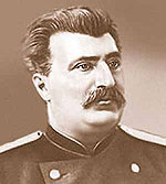 |
Local residents watched people passing by from the windows of their adobe homes. travelers. And they walked silently, their route among a hostile and restless local population. From time to time, people came to the travelers: hundreds of them knelt on both sides of the road, there were seriously ill people who came to ask for healing, old and young - everyone wanted to receive the blessings of the great white khubilgan (saint), that’s what they called Przhevalsky. As if it were the steppe wind that was blowing across Central Asia unusual rumors and myths about Przhevalsky and his companions: the Russian boss is a sorcerer or a saint, he needs to pray, because he knows everything in advance. Happy fate... made it possible to make a feasible exploration of the least known and most inaccessible countries of inner Asia. |
Indeed, the famous Russian geographer-traveler Nikolai Mikhailovich Przhevalsky was an amazing fate, did he know, while still a little rural boy, that such an extraordinary life, full of adventures and greatest discoveries, awaited him?
Was born N.M. Przhevalsky April 12, 1839 in the village of Kimbory, Smolensk province, in the family of a small landowner. Since childhood he was fascinated by the mysterious natural world, the boy's favorite pastime was reading books about travel and animals. Being an idealist, at the age of 16 he decides to enlist in the Belevsky regiment, but military affairs did not live up to the expectations of the young seeker: the endless revelry and unbridledness of the officers turned his views on life and humanity upside down. All his free time from service he is engaged in hunting, ornithology, and collecting herbariums. After five years in the regiment, Przhevalsky entered the Academy of the General Staff, the completion of which would give him the opportunity to finally do what he loved - travel. Having entered his studies, Przhevalsky became increasingly involved in creativity rather than military affairs; his course work “Military Statistical Review of the Amur Region” earned him membership in the Russian Geographical Society. This was the first step towards the life he dreamed of.
After graduating from the Academy Przhevalsky teaches at the Warsaw Junker School, while simultaneously doing science, writes a textbook on general geography for cadets. Africa at that time interested him most. However, he soon begins to be attracted central Asia: “I am confident that sooner or later I will realize my cherished dream of travel– writes N.M. Przhevalsky- intensively studied botany, zoology, physical geography, etc., and in the summer he went to his village, where he continued the same studies, collecting a herbarium" 1
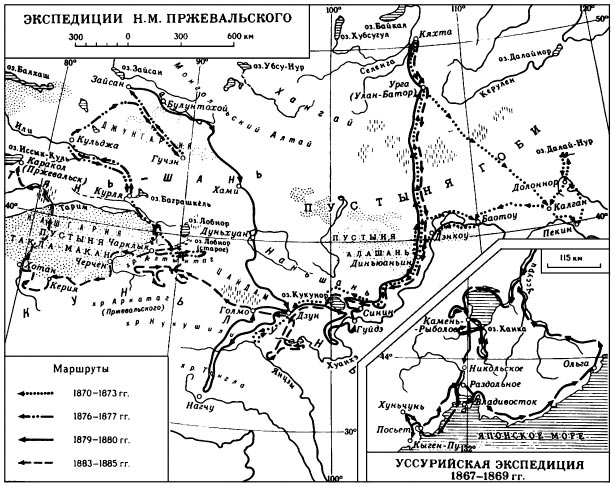 |
In 1867 Przhevalsky appeals to the Russian Geographical Society with a request to help organize an expedition to Central Asia, but, having no name in scientific circles, he, unfortunately, could not count on the support of the Society Council, which rejected his request. On the advice of P.P. Semenov – Tian-Shansky he decides to go to the Ussuri region, hoping to earn upon his return the long-awaited opportunity to assemble an expedition to Central Asia. The result of the two-year trip was the essays “On the foreign population in the southern part of the Amur region” and “ Journey in the Ussuri region,” as well as about 300 species of plants and birds, many of which were discovered in Ussuri for the first time. For the work done, the Russian Geographical Society awarded Przhevalsky a silver medal, but the main reward for the born researcher was the approval and assistance of the Geographical Society in organizing his next trip - already in Central Asia. |
First trip to Central Asia (1870 - 1873), called "Mongolian" turned out to be extremely difficult and dangerous. The expedition participants covered a total of more than 11,000 km. through Moscow, Irkutsk, Kyakhta, Beijing and north to Lake Dalai-Nur.
|
Having rested in Kalgan, Przhevalsky explored the Suma-Khodi and Yin-Shan ridges, as well as the course of the Yellow River (Huang He), showing that it does not have branches, as previously thought based on Chinese sources; passing through the Alashan and Alashan deserts mountains, he returned to Kalgan. On March 5, 1872, the expedition again set out from Kalgan and moved through the Alashan desert to the Nanshan ridges and further to Lake Kukunar. Then Przhevalsky crossed the Tsaidam Basin, overcame the Kunlun ridges and reached Tibet upper reaches of the Blue River (Yangtze). Summer 1873 Przhevalsky, having replenished his equipment, went to Urga (Ulaanbaatar), through the Middle Gobi, and from Urga in September 1873 he returned to Kyakhta. Three years of the most complex physical tests and, as a result, 4,000 plant specimens, new species were discovered that received his name: Przewalski's foot-and-mouth disease, Przewalski's split-tailed, Przewalski's rhododendron. This journey brought Nikolai Mikhailovich world fame and a gold medal from the Russian Geographical Society. As a report on my travel Przhevalsky writes the book “Mongolia and the Country of the Tanguts”. |
 PRZHEWALSKY'S FIRST VOYAGE |
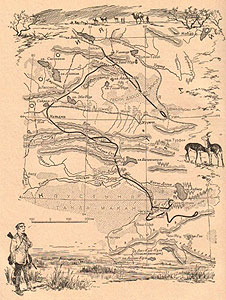 THE SECOND TRAVEL OF PRZHEVALSKY |
Yours second Central Asian trip Nikolai Mikhailovich Przhevalsky starts in 1876. It was conceived on a very large scale, it was supposed to explore Tibet and Lhassa, but due to the complications of the political situation (conflict with China) and the illness of Przhevalsky himself, the route had to be shortened. Having started his journey from Gulja, having overcome Tien Shan ranges and the Tarim Basin Przhevalsky reached the huge reed swamp-Lake Lop Nor in February 1877. According to his description, the lake was 100 kilometers long and 20 to 22 kilometers wide. On the shores of the mysterious Lop Nor, in the “land of Lop”, Przhevalsky was second... after Marco Polo! No obstacles prevented the researchers from making their discoveries: the lower reaches of the Tarim with a group of lakes and the Altyn-Tag ridge were described, and materials on the ethnography of the Lobnors (Karakurchins) were collected. After some time, an entry appears in Nikolai Mikhailovich’s diary: “A year will pass, misunderstandings with China will be settled, my health will improve, and then I will again take the pilgrim’s staff and again head to the Asian deserts” 2 |
|
Third Central Asian trip, named "Tibetan" Przhevalsky committed in 1879 - 1880 with a detachment of 13 people. The path lay through the Khamiya desert and Nan Shan ridge on the plateau Tibet. This expedition turned out to be surprisingly rich in discoveries. Its participants explored the Huang He River, the northern part Tibet, two ridges named Przhevalsky in honor of Humboldt and Ritter, the pika-eater bear, as well as the wild Dzungarian horse, which received the name in the scientific literature "Przewalski's Horses": “The newly discovered horse,” writes Nikolai Mikhailovich, is called kartag by the Kirghiz, and also by the Mongols, and lives only in the wildest parts of the Dzungarian desert. Here the kartags are kept in small herds, grazing under the supervision of an experienced old stallion" 3 Having received after this trips several honorary titles and titles and many recognitions and degrees, Przhevalsky, perhaps due to his natural modesty and rejection of the noisy, bustling city life, retires to the village, where he begins to process the collected material. My observations and research results Przhevalsky outlined in the book "From Zaisana through Hami V Tibet and the upper reaches of the Yellow River." |
 THE THIRD TRAVEL OF PRZHEWALSKY |
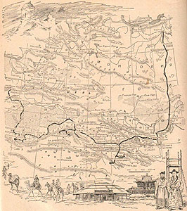 THE FOURTH TRAVEL OF PRZHEWALSKY |
Fourth Central Asian expedition was also known as the "Second Tibetan journey"and lasted from 1883 to 1885. And again Tibet! The Huang He River, dotted with key lakes, shining brightly in the rays of the setting sun, the swampy Yellow River, the sands of Alashan and Tarim; and new adventures and discoveries: lakes Orin-Nur, Dzharin-Nur, Moskovsky, Russian ridges, Columbus ridge, the sources of the Yellow River have been explored. New species of birds, mammals and reptiles, as well as fish appeared in the collection, and new plant species appeared in the herbarium. The result of this trips becomes another book, written in the rural silence of the Sloboda estate, “From Kyakhta to the sources of the Yellow River, a study of the northern outskirts Tibet and the path through Lob-nor along the Tarim basin.” For those who knew the character of the tireless Nikolai Mikhailovich, it was not surprising that at less than 50 years old he decided to go on his own fifth trip to Central Asia , which, alas, became the last for the outstanding scientist and researcher. |
Before leaving, Nikolai Mikhailovich went out onto the terrace of his estate and wrote on one of the columns in red pencil: “August 5, 1888. Goodbye, Sloboda! N. Przhevalsky." After which he called his companions and asked them all to sign: V. Roborovsky, P. Kozlov, Teleshev, Nefedov.
On August 18, accompanied by his closest friends, Nikolai Mikhailovich left St. Petersburg for the last time. As soon as the train started moving, he shouted through the open window F.D. Pleske, ornithologist: “If I’m gone, I’ll entrust the processing of the birds to you!”
On the train Przhevalsky continued to speak prophetic words, as if anticipating imminent death: “We are going to free, pleasant, glorious work. Now we are well armed and our life will not come cheap: it is pleasant to die for a glorious cause.”
This time the route ran along the Volga, the Caspian Sea to Krasnovodsk (now Turkmenbashi?), from there to Samarkand and Pishpek (Bishkek). From Pishpek to Alma-Ata. On the way to the Russian-Chinese border, while hunting in the valley of the Kara-Balta river, Przhevalsky Being already slightly cold, he drank river water and contracted typhoid fever.
In the last days of his life, Nikolai Mikhailovich behaved surprisingly courageously, did not lose heart and openly, consciously spoke about death, as if about an old acquaintance: “I’m not afraid of death, I’m ready to die, I’ve been face to face with death more than once...”
Having made several orders about his property, he bequeathed to bury himself on the shore Issyk-Kul.
Great October 20, 1888 traveler and a talented scientist-naturalist Nikolai Mikhailovich Przhevalsky gone. So his ashes remained forever in Asia, about which he dreamed all his life. In 1889, a monument was erected at his grave. On a block of granite rises a bronze eagle with an olive branch in its beak, ready to fly upward, as a symbol of the glory and greatness of a tireless, brave researcher who always moved forward towards his dream, who became an example for many, many generations of scientists and travelers Worldwide.
The article was prepared by SVETLANA SHCHEGLOVA
- The great Russian traveler Nikolai Mikhailovich Przhevalsky, Knigoizdat, 1948.
- Wikipedia
